Vantaan rakennettavuuskartta
WMS API
From the dataset abstract
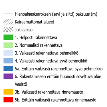
Constructability map commissioned by Geotekniikka for the Vantaa area for 2022. The constructability map shows constructability classes, special areas that are highly unsuitable for construction, such as riverbed zones and fill bogs, undisturbed areas, and curves of the thickness of the fine material layer (clay and silt) in metres.
The curve shows the thickness of the fine material layer (clay and silt) in the area. In places, sand and fill layers may be present on top of the fine aggregate layer.
For further information and feedback, please contact the City of Vantaa Geoservices.
The material can be viewed on the city of Vantaa map service:
Coordinate systems:
- Maintained in ETRS-GK25 (EPSG:3879)
API address:
- WMS: https://gis.vantaa.fi/geoserver/wms?request=GetCapabilities
- API description (in Finnish): https://gis.vantaa.fi/rajapinnat/
Layers:
- gis:rakennettavuus_2022
Source: Vantaan rakennettavuuskartta
Preview
There are no views created for this data resource yet.
Additional information
| Format | WMS |
|---|---|
| Coordinate system | ETRS-GK25 |
| Temporal Coverage | - |
| Data last updated | 19 February 2024 |
| Metadata last updated | 16 April 2025 |
| Created | 19 February 2024 |
| SHA256 | - |